
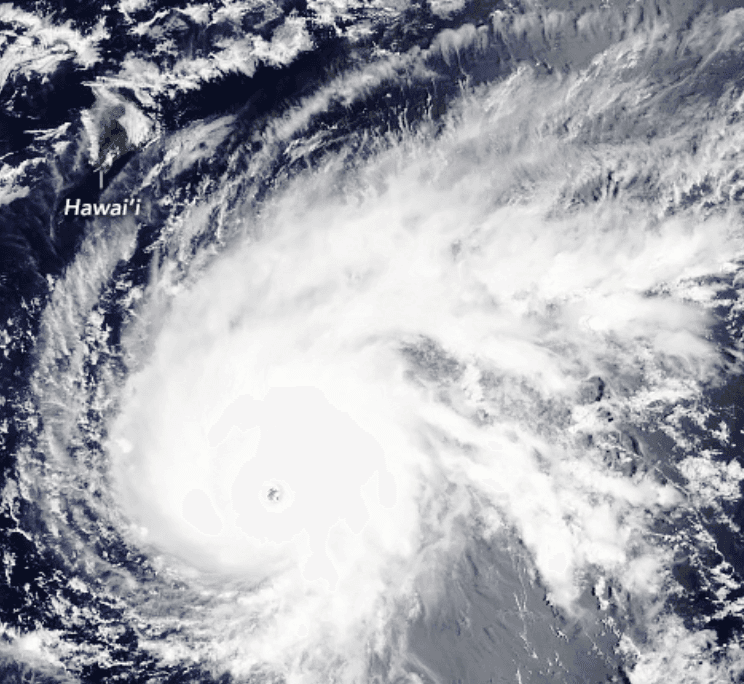
**Hurricane Lowell, a Category 4 system with 150 mph winds as of early September 5, 2026, is positioned roughly 625 miles south-southwest of Kauai and tracking west before a forecasted northward turn Sunday.** National Hurricane Center guidance and model consensus indicate the center will pass 100–200 nautical miles west of Kauai County late Monday or Monday night, crossing parts of the Papahanaumokuakea Marine National Monument offshore rather than the main Hawaiian Islands. This track stems from an initial mid-level ridge steering the storm westward, followed by erosion from a mid- to upper-level low that induces the north-northeast turn while keeping the system on the western side of the guidance envelope. Gradual weakening from increasing shear, cooler waters, and drier air is also expected by the closest approach, further reducing the chance of a direct hit. The 95.5% market-implied probability of no landfall reflects this strong consensus across official forecasts and ensembles, though modest uncertainty remains in the exact timing and latitude of the turn. A realistic scenario that could still produce landfall involves an eastward track shift of roughly 100 miles or more—possible given the slow-motion turn and spread in some model members—which would bring the core or right-front quadrant over Kauai or Niihau. Updated NHC forecasts and reconnaissance data through the weekend will be the key near-term drivers of any adjustment in trader sentiment.
Experimental AI-generated summary referencing Polymarket data. This is not trading advice and plays no role in how this market resolves. · UpdatedWill Hurricane Lowell make landfall in Hawaii?
Will Hurricane Lowell make landfall in Hawaii?
A hurricane is a tropical cyclone with maximum sustained winds of 74 mph or greater (Category 1 or higher on the Saffir-Simpson Hurricane Wind Scale), as described at https://www.nhc.noaa.gov/aboutsshws.php, and a hurricane landfall is said to occur when the hurricane's surface center intersects with the coastline, as described at https://www.nhc.noaa.gov/aboutgloss.shtml#LANDFALL. Lowell must hold hurricane strength (Category 1 or higher on the Saffir-Simpson scale) at the moment its surface center intersects the coastline for that landfall to qualify. If Lowell is classified as a tropical storm, a tropical depression, or a post-tropical cyclone at the moment its surface center intersects the coastline, this market will resolve to "No".
Whether a landfall occurred in Hawaii is determined solely by the official CPHC or NHC advisories. If those advisories report that Lowell made landfall in Hawaii, or on any island, atoll, reef, or shoal that those advisories identify as part of Hawaii, that landfall counts for the purposes of this market. This market applies no independent geographic definition of Hawaii, and no geographic boundary other than the one the CPHC or NHC advisories apply.
The wind speed at the moment of landfall will be determined from the CPHC or NHC advisory or Special Advisory in effect at the time closest to the reported landfall time; where no advisory covers that exact moment, the most recent advisory issued prior to landfall governs.
This market will resolve based on the initial CPHC or NHC advisory reporting a qualifying landfall regardless of any later advisory, retraction, best-track revision, or reanalysis that revises Lowell's intensity downward at the time of landfall. In the event that the CPHC or NHC do not publish landfall data for Hurricane Lowell by September 12, 2026 11:59 PM ET, or if the CPHC or NHC become unavailable, this market will resolve "No".
Market Opened: Sep 4, 2026, 12:02 PM ET
Resolver
0x65070BE91...A hurricane is a tropical cyclone with maximum sustained winds of 74 mph or greater (Category 1 or higher on the Saffir-Simpson Hurricane Wind Scale), as described at https://www.nhc.noaa.gov/aboutsshws.php, and a hurricane landfall is said to occur when the hurricane's surface center intersects with the coastline, as described at https://www.nhc.noaa.gov/aboutgloss.shtml#LANDFALL. Lowell must hold hurricane strength (Category 1 or higher on the Saffir-Simpson scale) at the moment its surface center intersects the coastline for that landfall to qualify. If Lowell is classified as a tropical storm, a tropical depression, or a post-tropical cyclone at the moment its surface center intersects the coastline, this market will resolve to "No".
Whether a landfall occurred in Hawaii is determined solely by the official CPHC or NHC advisories. If those advisories report that Lowell made landfall in Hawaii, or on any island, atoll, reef, or shoal that those advisories identify as part of Hawaii, that landfall counts for the purposes of this market. This market applies no independent geographic definition of Hawaii, and no geographic boundary other than the one the CPHC or NHC advisories apply.
The wind speed at the moment of landfall will be determined from the CPHC or NHC advisory or Special Advisory in effect at the time closest to the reported landfall time; where no advisory covers that exact moment, the most recent advisory issued prior to landfall governs.
This market will resolve based on the initial CPHC or NHC advisory reporting a qualifying landfall regardless of any later advisory, retraction, best-track revision, or reanalysis that revises Lowell's intensity downward at the time of landfall. In the event that the CPHC or NHC do not publish landfall data for Hurricane Lowell by September 12, 2026 11:59 PM ET, or if the CPHC or NHC become unavailable, this market will resolve "No".
Resolver
0x65070BE91...**Hurricane Lowell, a Category 4 system with 150 mph winds as of early September 5, 2026, is positioned roughly 625 miles south-southwest of Kauai and tracking west before a forecasted northward turn Sunday.** National Hurricane Center guidance and model consensus indicate the center will pass 100–200 nautical miles west of Kauai County late Monday or Monday night, crossing parts of the Papahanaumokuakea Marine National Monument offshore rather than the main Hawaiian Islands. This track stems from an initial mid-level ridge steering the storm westward, followed by erosion from a mid- to upper-level low that induces the north-northeast turn while keeping the system on the western side of the guidance envelope. Gradual weakening from increasing shear, cooler waters, and drier air is also expected by the closest approach, further reducing the chance of a direct hit. The 95.5% market-implied probability of no landfall reflects this strong consensus across official forecasts and ensembles, though modest uncertainty remains in the exact timing and latitude of the turn. A realistic scenario that could still produce landfall involves an eastward track shift of roughly 100 miles or more—possible given the slow-motion turn and spread in some model members—which would bring the core or right-front quadrant over Kauai or Niihau. Updated NHC forecasts and reconnaissance data through the weekend will be the key near-term drivers of any adjustment in trader sentiment.
Experimental AI-generated summary referencing Polymarket data. This is not trading advice and plays no role in how this market resolves. · Updated

Beware of external links.
Beware of external links.
Frequently Asked Questions